
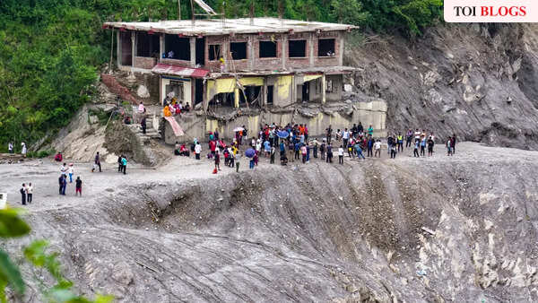
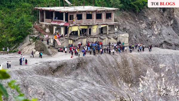
The chief customs officer at Rasuwagadhi felt the ground move on Wednesday morning and went outside expecting an earthquake. What he found was a wall of water coming down on Timure bazaar. He has since described the market disappearing in the space of a few moments.By Saturday morning Nepal Police had counted 616 dead and listed 1,924 missing, with damage put provisionally at Rs 200 billion. Somewhere in that arithmetic is a woman in Rasuwa who spent days moving between shelters looking for two children she assumed were gone, and who eventually found both alive. Somewhere in it too are the hundred-odd people rescuers dug out of the tunnels of a hydropower plant.Three days on, we still cannot say with confidence what caused any of it. That is not a failure of science. It is what this category of disaster looks like from the inside, and it has uncomfortable implications for how early warning gets built, here and in the global programme meant to cover everyone on earth by the end of next year.
Working out what happened
The first reports said earthquake. Seismographs had registered something large, and that is the explanation the instruments seemed to offer. Analysis of long-period waves by the United States Geological Survey pointed elsewhere: the signature belonged to an enormous mass in motion, not to rock fracturing along a fault. Attention turned to a glacier around 610 metres across, on the northern flanks of Langtang Lirung and Tsangbu Ri, which appears to have let go and fallen some 1,200 metres.After that it stopped being an event and became a sequence. Ice and rock piled into the Lhende valley and dammed the river. Water gathered behind the debris. The dam failed, and what came out of it went down the Bhotekoshi and into the Trishuli at an average of 193 kilometres an hour over the first twenty-two kilometres.Other mechanisms are still in play. A supraglacial lake may have failed as well, and Ujjwal Upadhyaya has cautioned that no single process comfortably accounts for destruction on this scale. Rijan Bhakta Kayastha at Kathmandu University ruled out rainfall as a primary driver within a day.The ambiguity is not academic. Two very different processes can flatten the same village. One builds over months, as meltwater accumulates behind a moraine that gradually stops holding. The other takes seconds, when ice loses its grip on a mountainside. They leave similar wreckage and demand entirely different instruments to anticipate, so you cannot design a detection system until you know which one you are watching for. And the file is thickening. The Lhende flooded damagingly in July last year, blamed on a supraglacial lake. Tilgau in Humla lost a glacial lake in May 2025. None arrived with rain. These were clear-day disasters, which is exactly why flood forecasting, built around weather, did not see them coming.
What held up
More than the headlines suggest. Earth observation carried the investigation almost single-handedly: Sentinel, ISRO and commercial imagery fixed the location and rough shape of the collapse within days, and before-and-after scenes showed the blockage about twenty kilometres above the Miteri bridge. Seismology did something better than forensics — it corrected a wrong answer, which is the harder and more useful job. ICIMOD moved scientific information across the region while official channels were finding their feet. Drones and fast visualisation gave responders a picture of ground helicopters kept being turned back from.Nepal’s own institutions were quite active. The Flood Forecasting Division put out a downstream warning four minutes after it learned anything at all. Four minutes is a good reflex by the standards of any agency anywhere.
What gave way
Four minutes was still too late, and the reason deserves attention. Nepal had installed automatic monitoring stations in the upper Bhotekoshi for precisely this contingency. The flood destroyed them before a single one reported. Instruments on Nepali soil, paid for and placed by Nepal, were taken out by the thing they existed to see coming. Around 120 telecom towers went down across Rasuwa, Nuwakot and Dhading, removing the means of telling anyone anyway. Two lessons follow directly: put sensors where they will survive what they monitor, with redundancy above the hazard zone, and build dissemination that outlives the disaster, which means a satellite fallback for the hour the towers go down.
One corridor, three jurisdictions
Follow the water and the case for treating this basin as one system makes itself. The ice failed high above the Lhende. The surge went down the Bhotekoshi into the Trishuli, and bodies have been recovered in Rasuwa, Nuwakot, Dhading, Chitwan, Gorkha, Tanahun and both Nawalparasis, a trail several hundred kilometres long. The Trishuli becomes the Narayani. The Narayani crosses into India as the Gandak. At Valmikinagar in West Champaran (Bihar), engineers opened all thirty-six gates of the barrage, and discharge peaked near 1.5 lakh cusecs on Wednesday night.One mass of ice, one morning, three jurisdictions. Water managers in Bihar spent the day reading a gauge at Devghat and counting on a travel time of about three and a half hours. That is what a risk corridor is in practice: something starting in high glaciated terrain, moving through a middle-mountain river system, finishing on a crowded plain in another country. Each stretch can be run competently and the corridor still fail as a whole, because nobody is responsible for the whole.
Taking it forward
None of what follows needs new institutions. It needs the ones we have to work along the corridor rather than within their own stretch of it.Start with a shared list of catchments worth worrying about, an agreed rhythm for checking them, and named people whose job it is to look. ICIMOD has both the convening ability and, on this evidence, the instincts.Agree what counts as reportable. A blocked channel, an unstable barrier lake, an ice-rock avalanche should mean the same thing and trigger the same message at every point along the river. Cryospheric and geomorphic hazards need detection logic of their own, not a seat at the edge of the meteorological table.Make alerts machine-readable across borders, through the Common Alerting Protocol, so a message written by one agency does not need a phone call and a translation to be useful to the next.Model travel time and attenuation jointly, so a barrage operator downstream knows what is actually coming and when, and warnings can be pitched to real severity instead of worst case.Then rehearse it, including the second event. Two million cubic metres of water are sitting behind avalanche debris upstream as I write. Watching that is as urgent as the recovery.
What it means for early warnings for all
The UN initiative promises universal early warning coverage by the end of 2027, across four pillars: risk knowledge, detection and forecasting, dissemination, preparedness. But its stated scope runs to hydrometeorological, climatological and related environmental hazards, and a glacier failing on a clear day sits awkwardly inside that description. Pillar 2 is organised around forecasting. This hazard could not be forecast in any meaningful sense. It could have been detected within minutes, by seismic and satellite systems that already exist and are wired into no warning chain at all.The gap is worth naming while it can still be closed. Consultation on where EW4All goes after 2027 runs until December this year. Mountain regions should use it to insist that multi-hazard means what it says, that detection belongs beside forecasting at the centre of Pillar 2, and that when a hazard corridor crosses borders, the warning system has to be designed at the scale of the corridor rather than the country.Nepal has paid an appalling price to make the point. The least the rest of us can do is treat it as evidence.
Disclaimer: Views expressed above are the author’s own.